
Assessing the Kingston East Landfill Site using ERT, EM-31, and GPR methods
Project, Queen's University, Canada, 2021
Title: Assessing the Kingston East Landfill Site using ERT, EM-31, and GPR methods 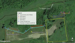 ”
”
Abstract:
Inappropriate management of landfill waste is a huge problem worldwide. In regions where precipitation changes seasonally, contaminants leach out of landfill waste and migrate through the subsurface channels into the groundwater or surface water. This poses health threats to human civilization, plants, and animals in the surrounding environment. Therefore, mapping and monitoring the contaminants’ path from the waste site is essential for effective management and remediation. The movement of contaminants causes changes in the subsurface conductivity, which can be measured using different geophysical tools. In this study, we employed the combination of Ground-penetrating radar (GPR), Electromagnetics (EM-31), and electrical resistivity tomography (ERT) methods to understand the subsurface dynamics of the Kingston East landfill site, which received industrial and domestic waste for over four decades (1970-2013). An inverted 2D ERT section at the new landfill site shows the variations in low resistivity from 22–27 $\Omega\cdot$m to 40-49 $\Omega\cdot$m which likely represents water saturated silt and gravel respectively, which is also observed in EM-31 data. Also, at the old landfill site, soil cover and pond filled with clay shows the resistivity variation of 36.27 $\Omega\cdot$m and 17.26 $\Omega\cdot$m at a depth of 1.09 m and 1.18 were observed.
Summary:
- The results from the GPR, EM-31, and Electrical resistivity show the presence of a highly conductive layer representing the garbage layer found at a depth of approxi- mately 0.75m.
- Also at the old landfill site, The Soil cover and pond filled with clay were successfully demarcated along the former pond side. These results also allowed us to demarcate the boundaries between former landfill sites and non-landfill sites